


Geology Site Account
A-Z Geological Site Index
Southend cliffs and landslips, SOUTHEND, Southend District, TQ875851, General geological site
|
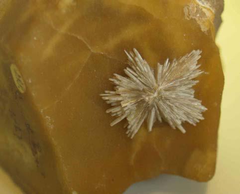
Site category: Landform or landslip Between Hadleigh Castle and Southend Pier (TQ 872 852 to TQ 884 851), a distance of over 7 kilometres (4½ miles), the coastline takes the form of a line of cliffs up to 30 metres (100 feet) high of London Clay, overlain by Ice Age sand and gravel and river alluvium. In common with London Clay cliffs elsewhere, especially on the Isle of Sheppey on the other side of the estuary, the cliffs are susceptible to major landslips. Before the development of Southend in the nineteenth century this coastline was under constant attack by the sea and would have consisted of tumbled and vegetated slopes with mud flows and large masses of London Clay moving seawards along slip planes lubricated by groundwater. Even today, the movement of the ground along much of the Southend coastline is still a constant problem for the Council engineers, the most serious landslips occurring at The Cliffs, a section of coast just over a kilometre (approximately ¾ mile) long between the Cliffs Pavilion and Southend Pier. Since the sea wall and promenade were built in 1902 the cliffs have mostly been laid out as public gardens but this has not prevented the landslipping. The cliffs here are fairly steep (up to 30 degrees in places) and despite extensive attempts at underground drainage the ground frequently creeps forward which results in cracked paths and leaning lamp posts and trees. Occasionally there are major landslips such as the one that occurred in December 2002 which was 180 metres (600 feet) wide and destroyed large areas of the gardens, threatened the bandstand and temporarily closed two lanes of the sea front dual carriageway. The landslips do, however, occasionally give us a glimpse of the underlying rocks, particularly the London Clay, which here contains layers of septarian nodules. A piece of a septarian nodule from Southend, containing a fine group of radiating crystals of the mineral barite, is on permanent display in the British Minerals section of the Mineral Gallery in the Natural History Museum, London.
see also: A fragment of a septarian nodule from Southend, containing a fine group of white barite crystals on yellow calcite. This specimen is on permanent display in the 'British Minerals' section of the Mineral Gallery in the Natural History Museum, London. Photo: G.Lucy |
if you have an image please upload it
|

Reference: Greensmith 2003, Hutchinson 1965 (p.13-22), Lucy 2012 (p.122-123 & plate 38)
Geology Site Map
A-Z Geological Site Index